Showing posts with label Hackberry Canyon. Show all posts

Tuesday, May 8, 2018

On to Bryce Canyon National Park, just up the Road.

Monday, April 9th, 2018 to Friday, 13th April; Bryce Canyon National Park.


After the rain, road out probably would have been OK to attempt on the Sunday, but I came out on the Monday, nevertheless, and the road was just fine.  Proceeding the rest of the way through Cottonwood Canyon, I stopped briefly, on my way to Bryce Canyon National Park, in the small town of Tropic for a few supplies.  Next to the combination grocery store and petrol station, there was also a hardware store, so I popped in to pick up a mouse trap.  Yes folks, after all these years of camping in the mountains, forests and deserts of the Pacific Northwest, east to the Upper Peninsula of Michigan and across the Great Plains and Sand Hills of Nebraska, into the Rocky Mountains of Colorado and Wyoming, and as far south as East central Arizona, I finally had a desert mouse hitch a ride with me for four days. 

I`m pretty sure it was on Thursday night, after my walk through the Hackberry Canyon, when it was so warm that I sat in the driver’s seat with the door open, drinking my hot chocolate, and working on my blog, that he jumped into the truck.  I remember lying on my back in the Boundary Waters Canoe Area Wilderness (BWCAW), back in `93, with my Brother Doug, his wife Karin, and my Mom, counting meteors of the Perseid Meteor Shower, when every so often the occasional deer mouse would land on the middle of my chest, at the end of his leap … yes, some mice can jump.

I did not see this desert mouse enter the vehicle, and I wasn't sure that there was one with me until two mornings later, when I found some paper towels that had been nibbled on.  But, on the night in question, sitting in the dark with the door open, I was startled when I thought I felt something land on my left knee.  And then a couple more times that evening, and the next, I thought I felt something on my leg, but saw nothing by the time I got my headlamp turned on.  As I say, the nibbled paper gave it away, as well as a couple of droppings.  So on the Monday, I set two traps, baited with chocolate covered raisins, and placed one on the dash board and one on the floor of the driver’s seat, before turning in.  As I was dropping off to sleep, I heard one go.  Thus roused, I checked which one had gone off, and it was the one in the footwell, so stretching down I opened the door and tossed it out into the night to deal with in the morning … the other one remained set all night, so it was just the one.  Chocolate covered raisins have never let me down in any house in which I’ve ever needed to use a trap; and now out in the wild … gets `em every time.  I have heard of traps that catch them alive, and I will have to look into that as I do not wish to kill the wildlife, but I could not have this critter infesting my truck … I mean … four days with him was enough!


(Take Note: for those of you who have signed up to be notified by email of new postings to this blog, you have been receiving not just a notification, but an actual copy of the new blog posting as the email.  As this does not show the images of the paintings in the best possible light, you should click on the title of the latest blog posting at the top of the post, and not the title of the painting itself; this will open up the actual blog itself, and you may then enjoy the paintings at their best.)


First glimpse of Bryce Canyon.
ß  Note the pinkish orange; the Sinking Ship (yes, the Grand Canyon doesn’t have a monopoly on sinking ships), is the slanted butte in the distance.  On the horizon is the Aquarius Plateau, 30 miles distant.  The rock formations are the same, but it is at ten thousand feet, whereas we are at eight; the Paria Fault lies between and where we are standing has dropped two thousand feet.


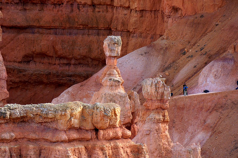
There is more to Bryce Canyon National Park than I had thought; but then I didn’t know much more about it than the postcard I had once received, and a few photos I had seen, on occasion, over the years, here and there.  The pink and white sandstones of the Clarion Formation form the topmost riser of the Grand Staircase Escalante, known as the pink cliffs, and Bryce Canyon National Park occupies one section of these pink cliffs, where the conditions were just right for the formation of the myriad, phantasmal sandstone columns known as hoodoos.  If you remember my couple of days spent in Recapture Pocket, east of Bluff, Utah, amongst the more personal sized hoodoos you will already be familiar with these formations.  What sets Bryce Canyon apart is not only the shear size and quantity of these formations, but the beauty of their pastel pinks, oranges yellows and whites, forming a veritable fairyland.  They positively glow, with direct and reflected light.  It is this pastel glow, seemingly from within, that sets this place apart from all the iterations that the red rock country displays throughout Utah and the southwest.  What I really like about Bryce is the complementary contrasts between the orange/pink rocks and the forest greens.
 

  The photographs will speak for themselves.


Sinking Ship & Aquarius Plateau.


Hey ... it's my Hammer (Thor's Hammer)!


Heading …

…down …

… into …

… the …

… Canyon.


And of course just after I thought it safe to put away my Winter clothes, the old man Frost pulls off another blast, forcing me into my long-johns, and breaking out the Sorel boots and mad-trappers hat, once again, on Thursday April 12th!  The cold, windy conditions, and snow showers seemed to bring the deer out to graze along the Park roads, and several Pronghorns were spotted as well.  Cold and partly sunny when I left on Friday, and as I took State Hwy 14 to Cedar City, passing the south entry road (closed), leading to Cedar Breaks National Monument, the high country was still completely snow covered, and Navajo Lake was still completely frozen over.  Bryce is between 8000’, rising to 9000', in altitude, but Hwy 14 rises to around 10,000', but I still did not expect that amount of snow up there.  That night's camp was about thirty miles south of Cedar City (where I replaced my phone, which had died on April 1st), just inside the Dixie National Forest, at about 4200'; much warmer, and the Winter clothes have once again been shed.


Yep! That’s ‘er awright!


View from the depths.


Hey, that’s my Hammer again!

And again with the Sinking
Ship in the distance.


The one that got away
(Only two stripes on this Chipmunk/Ground Squirrel(?).


Cathedral.

Window.

Here comes that Snow again.


Arches National Park
doesn’t have ‘em all.
Navajo Lake near Cedar Breaks National Monument.

Cold & blowy up here!


About 35 miles west of Bryce, as the Raven flies, and a couple thousand feet higher ... altitude makes all the difference!

Friday, May 4, 2018

A Taste of the Grand Staircase Escalante National Monument.

Thursday, April 5th, 2018 to Monday, 9th April; 
Cottonwood Canyon in the Grand Staircase Escalante National Monument.


(Take Note: for those of you who have signed up to be notified by email of new postings to this blog, you have been receiving not just a notification, but an actual copy of the new blog posting as the email.  As this does not show the images of the paintings in the best possible light, you should click on the title of the latest blog posting at the top of the post, and not the title of the painting itself; this will open up the actual blog itself, and you may then enjoy the paintings at their best.)


After five days of not seeing or hearing a vehicle, I left my Buckskin Mountain campsite, and slowly came down from the mountain; slowly being the operative word as that road is a desperate four miles of rocks, and ruts, and ledges and strange angles.  Three miles along the way I spotted an old quarry just off the east side of the road, or so I thought.  It turned out to be Eagle Sink, and is a natural feature, although it looks for all the world like an abandoned quarry.  I never saw it going in last Saturday, as I was concentrating on the road. “Rattlesnake heaven,” according to the lady at the BLM Office down Hwy 89 from there.  I expect they'll be out soon, as it's warming up in these parts.  Just a few miles to the east, after rejoining the highway, there's the road to Paria Township site, and also near the site of the movie set of the small town towards the end of “The Outlaw Josie Wales.”  Nothing there now, except some info signs, a loo, a picnic table, and a lot of interesting geology. 

Eagle Sink …
evidently rattlesnake heaven …
saw not a one.


On the way out from the old movie set.


Farther east over the ridge from Old Paria, is Cottonwood Wash, and yet more interesting geology, and I have a small publication all about it.  Tonight's camp is about 12 miles up the wash, next to a large slab of Jurassic Entrada Sandstone, across a small valley from several hogbacks of Cretaceous Dakota Sandstone, with the stars shining brightly.  On the way in I stopped to gather oysters for my supper, but the oyster-bed turned out to be ninety-some million years old; just a tad past their sell-by date, so I left these petrified suckers be … damn, coulda used some shellfish for me tea!


Between my Pinkie & thumb is a gap of 60 million years
in the strata; this is known as an unconformity.

Petrified Oysters.

Oyster-bed above a seam of coal (where the lower shadow is);
below that is Dakota Sandstone; this series represents a change
from river deposition to swamps, to brackish water,
where the oyster-beds are.

What left these tracks?

Oh!  You did.

Local lounge lizard …
the larger of the two types in this area.


While breakfasting the next morning, I was looking at the sloping strata of the Dakota Sandstone across the valley, and wondering if the oyster-beds were also in evidence there.  After breakfast I drove through Dakota hogbacks and took a look.  Sure enough, there were the oyster-beds at the junction of the Dakota Sandstone and the Tropic Shale (they were also found again two miles back down the road, when I went back for a look at the Geology I had passed by last evening).  Here the strata is steeply sloped to the east, whereas 9.5 miles back down the road where I first encountered them the strata was still level.  Here the rock layers have been bent over the East Kaibab Monocline along an underground fault, much as a tablecloth over the edge of a table, as the Grand Staircase Escalante to the west of this fault line has been uplifted.  Cottonwood Wash, up which I am driving, follows this fault line, and the tilted strata along here has formed a series of hogbacks through erosion, and is known as the Cockscomb for its resemblance to the serrated comb on the head of a chicken.


Entering Hackberry Canyon.

Cross-bedded Navajo Sandstone …
these are ancient dunes.

Some sort of Penstemon.


Much of the time you are walking in the stream, which on this day was half inch deep for the most part, and where slightly deeper easily stepped across.

To the east and west of Cottonwood wash the rock layers lie level, and the tilted layers along the Cockscomb are only a couple of miles or so in width.  I observed this first hand by taking a walk west through Hackberry Canyon for three miles.  At the beginning of the hike the strata is sharply tilted, but by the end of it has leveled out.  By the time I turned around where the Chinle formations were in evidence, I had walked through 60 million years of time, to when the early dinosaurs were inconsequential creatures (225 million years ago), from when they had become the large sauropods and carnivores at the beginning of my walk.  As I retraced my steps back down the canyon, I was now proceeding forwards in time, and at about the 190 million year area, I managed to find the boulder from the Moenave formation, that had some early dinosaur tracks on it.  This beastie who made these tracks was about six feet in height, so I reckon my bear spray might well stop it, should I encounter one next time I use my time machine, once it's repaired.

I brought out the colours in this one,
but with the naked eye and it fluttering along,
it looks black with yellow trimming.

About a mile into the Canyon.

The leaves within the canyon
were further along than those outside of it.

Here the Canyon widens out
at about 1½ miles in.


The lower slopes (in above photo),  are of the Chinle formation and about 60 million years older than the Navajo Sandstone at the canyon entrance.  The Red cliffs above the Chinle slopes are Jurassic Moenave and Kayenta formations, with the whiter Navajo on the skyline.  Note that by the time we reach this point in the Canyon, the strata has leveled out, indicating we have passed through the strata draped over the buried fault that lies beneath Cottonwood Canyon, that I had driven up the day before and where I am now camped.


Small dinosaur tracks in a
Monave formation boulder … my knife about 10”.

Denizen.

Sorry to have bored you silly with all the Geology, but that is much of what the Southwest is all about … you can’t ignore it.  And gaining a bit of knowledge about what I am seeing, whether geology, plants, wildlife, or the ancient ruins I encounter, all enhance these experiences.  That's why I was pleased as punch when I took what little I had learned about the first oyster bed I encountered, and idly wondered if they might be in the same situation near my campsite, and then found that they were!


About a mile to go.


Almost back out of Hackberry Canyon.


But apart from the Geology lesson, the walk through Hackberry Canyon was beautiful; splashing through the shallow streambed (managing to step over those channels that were more than an inch deep); observing my fourth wild flower in bloom this Spring (some variety of red Penstamen); noting that the new leaves on the Cottonwoods were slightly more advanced in the more sheltered, narrow depths of the Canyon, than at either end; spotting black butterflies, with yellow wing edges, that on close inspection through my binoculars, turned out to be not so much black, as a deep purple russet, and as the direction of the light on it changed, there seemed to be a pattern similar to a Small Tortoiseshell Butterfly, I was familiar with in England … but the naked eye impression is of black and yellow.  Yes … it was a good walk.  I returned to my secluded camp of the previous night, only about a half mile from the Hackberry Canyon Trailhead.


View from my campsite … hogbacks are evident.