Showing posts with label Grand Canyon. Show all posts

Tuesday, May 8, 2018

On to Bryce Canyon National Park, just up the Road.

Monday, April 9th, 2018 to Friday, 13th April; Bryce Canyon National Park.


After the rain, road out probably would have been OK to attempt on the Sunday, but I came out on the Monday, nevertheless, and the road was just fine.  Proceeding the rest of the way through Cottonwood Canyon, I stopped briefly, on my way to Bryce Canyon National Park, in the small town of Tropic for a few supplies.  Next to the combination grocery store and petrol station, there was also a hardware store, so I popped in to pick up a mouse trap.  Yes folks, after all these years of camping in the mountains, forests and deserts of the Pacific Northwest, east to the Upper Peninsula of Michigan and across the Great Plains and Sand Hills of Nebraska, into the Rocky Mountains of Colorado and Wyoming, and as far south as East central Arizona, I finally had a desert mouse hitch a ride with me for four days. 

I`m pretty sure it was on Thursday night, after my walk through the Hackberry Canyon, when it was so warm that I sat in the driver’s seat with the door open, drinking my hot chocolate, and working on my blog, that he jumped into the truck.  I remember lying on my back in the Boundary Waters Canoe Area Wilderness (BWCAW), back in `93, with my Brother Doug, his wife Karin, and my Mom, counting meteors of the Perseid Meteor Shower, when every so often the occasional deer mouse would land on the middle of my chest, at the end of his leap … yes, some mice can jump.

I did not see this desert mouse enter the vehicle, and I wasn't sure that there was one with me until two mornings later, when I found some paper towels that had been nibbled on.  But, on the night in question, sitting in the dark with the door open, I was startled when I thought I felt something land on my left knee.  And then a couple more times that evening, and the next, I thought I felt something on my leg, but saw nothing by the time I got my headlamp turned on.  As I say, the nibbled paper gave it away, as well as a couple of droppings.  So on the Monday, I set two traps, baited with chocolate covered raisins, and placed one on the dash board and one on the floor of the driver’s seat, before turning in.  As I was dropping off to sleep, I heard one go.  Thus roused, I checked which one had gone off, and it was the one in the footwell, so stretching down I opened the door and tossed it out into the night to deal with in the morning … the other one remained set all night, so it was just the one.  Chocolate covered raisins have never let me down in any house in which I’ve ever needed to use a trap; and now out in the wild … gets `em every time.  I have heard of traps that catch them alive, and I will have to look into that as I do not wish to kill the wildlife, but I could not have this critter infesting my truck … I mean … four days with him was enough!


(Take Note: for those of you who have signed up to be notified by email of new postings to this blog, you have been receiving not just a notification, but an actual copy of the new blog posting as the email.  As this does not show the images of the paintings in the best possible light, you should click on the title of the latest blog posting at the top of the post, and not the title of the painting itself; this will open up the actual blog itself, and you may then enjoy the paintings at their best.)


First glimpse of Bryce Canyon.
ß  Note the pinkish orange; the Sinking Ship (yes, the Grand Canyon doesn’t have a monopoly on sinking ships), is the slanted butte in the distance.  On the horizon is the Aquarius Plateau, 30 miles distant.  The rock formations are the same, but it is at ten thousand feet, whereas we are at eight; the Paria Fault lies between and where we are standing has dropped two thousand feet.


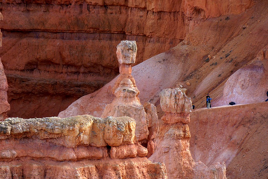
There is more to Bryce Canyon National Park than I had thought; but then I didn’t know much more about it than the postcard I had once received, and a few photos I had seen, on occasion, over the years, here and there.  The pink and white sandstones of the Clarion Formation form the topmost riser of the Grand Staircase Escalante, known as the pink cliffs, and Bryce Canyon National Park occupies one section of these pink cliffs, where the conditions were just right for the formation of the myriad, phantasmal sandstone columns known as hoodoos.  If you remember my couple of days spent in Recapture Pocket, east of Bluff, Utah, amongst the more personal sized hoodoos you will already be familiar with these formations.  What sets Bryce Canyon apart is not only the shear size and quantity of these formations, but the beauty of their pastel pinks, oranges yellows and whites, forming a veritable fairyland.  They positively glow, with direct and reflected light.  It is this pastel glow, seemingly from within, that sets this place apart from all the iterations that the red rock country displays throughout Utah and the southwest.  What I really like about Bryce is the complementary contrasts between the orange/pink rocks and the forest greens.
 

  The photographs will speak for themselves.


Sinking Ship & Aquarius Plateau.


Hey ... it's my Hammer (Thor's Hammer)!


Heading …

…down …

… into …

… the …

… Canyon.


And of course just after I thought it safe to put away my Winter clothes, the old man Frost pulls off another blast, forcing me into my long-johns, and breaking out the Sorel boots and mad-trappers hat, once again, on Thursday April 12th!  The cold, windy conditions, and snow showers seemed to bring the deer out to graze along the Park roads, and several Pronghorns were spotted as well.  Cold and partly sunny when I left on Friday, and as I took State Hwy 14 to Cedar City, passing the south entry road (closed), leading to Cedar Breaks National Monument, the high country was still completely snow covered, and Navajo Lake was still completely frozen over.  Bryce is between 8000’, rising to 9000', in altitude, but Hwy 14 rises to around 10,000', but I still did not expect that amount of snow up there.  That night's camp was about thirty miles south of Cedar City (where I replaced my phone, which had died on April 1st), just inside the Dixie National Forest, at about 4200'; much warmer, and the Winter clothes have once again been shed.


Yep! That’s ‘er awright!


View from the depths.


Hey, that’s my Hammer again!

And again with the Sinking
Ship in the distance.


The one that got away
(Only two stripes on this Chipmunk/Ground Squirrel(?).


Cathedral.

Window.

Here comes that Snow again.


Arches National Park
doesn’t have ‘em all.
Navajo Lake near Cedar Breaks National Monument.

Cold & blowy up here!


About 35 miles west of Bryce, as the Raven flies, and a couple thousand feet higher ... altitude makes all the difference!

Wednesday, May 2, 2018

Vermillion Cliffs, Paria Plateau & the White Pocket.

Tuesday, March 27th, 2018 to Wednesday, 4th April; Vermillion Cliffs & beyond.

(Take Note: for those of you who have signed up to be notified by email of new postings to this blog, you have been receiving not just a notification, but an actual copy of the new blog posting as the email.  As this does not show the images of the paintings in the best possible light, you should click on the title of the latest blog posting at the top of the post, and not the title of the painting itself; this will open up the actual blog itself, and you may then enjoy the paintings at their best.)


From Desert View Overlook in the Grand Canyon, Vermillion Cliffs National Monument can be seen 46 miles to the north, although farther by road.  This is where I now headed (Tuesday, 27th March), on US 89 and 89A.  To the east loomed the long escarpments of Hamblin Ridge and Echo Cliffs, high above me.  Crossing the Colorado on Navajo Bridge at Marble Canyon, I turned right to Lee’s Ferry, the official beginning of the 277 mile long Grand Canyon.  I spent less than an hour here, noting a few features in the landscape, and historical sites that I had read about in a small book last July at my friend Martin's house.  There was also a group of rafters preparing to head into that Canyon.  From Lee's Ferry I rejoined 89A and about 10 miles along I found my campsite for the night, a mile in from the highway.  Here I was kept busy until after sundown photographing the flaming light on both the Echo Cliffs, across the valley to the east, and the Vermillion Cliffs looming above me, although much of the latter were in evening shadow.  In the morning it was all about the rising Sun on Vermillion Cliffs.

Vermillion Cliffs from the East

Colorado River from the Navajo Bridge

The following are at Lee's Ferry, 5 mles up from Navajo Bridge.


Late afternoon, Vermillion Cliffs and on Echo Cliffs, to the east. And then evening glow on Echo Cliffs.  

Next morning Rosie-fingered Dawn comes upon Vermillion Cliffs.


A house, ruinous now, built around a boulder!  It was just by the roadside & I know nothing about it.


Something took a bite from this cactus on the way down into the arroyo.


Echo Cliffs from about 20 miles

Twenty-something miles down the road I turned north onto House Rock Road, a wash-board of a gravel road, and a couple miles along had lunch at the Condor Viewing Site.  And there were Condors, at least a pair, soaring around the clifftops, a couple miles away and 2000 feet above, near the original 1996 release site.  From this distance even through my binoculars they looked sparrow sized, and the odd Raven that was occasionally worrying them even smaller.  You wouldn't have thought they have a wing spread of nine feet!  There were about a dozen other people spotting them with their scopes.  My view of the Condor I spotted in the Grand Canyon was better, being closer, but this was interesting to see them soaring and flapping their wings even at this distance.  I took a couple of photos with the zoom fully extended at 1200mm.

Southwestern Vermillion Cliffs …

… here be Condors
And so on to the White Pocket on the Paria Plateau, which is on top of the Vermillion Cliffs.  Back in October 2013 I attempted to find this feature with very sketchy information and failed, ending up driving thirty miles in 4-wheel through sand.  I managed a painting and got a feel for the Plateau, but did not achieve the original objective.  This time I had better information and got the right road, at the fork where I went wrong last time.  Here I met a couple coming out who gave me an heads-up on the conditions of the road ahead, and also a basic chart of the forest roads.  I think I would have got there without it, but having it was a comfort nonetheless.  Did I have a shovel, they asked, and I told them I did, and an axe, a bow-saw, chains, water food, etc.  You’ll be alright they said, especially after I told them about my adventure of 2013.  They warned me to keep an eye out for vehicles coming out as there were about half a dozen cars up there.  From here it was about ten miles of sometimes deep sand, single tracked, and with the very occasional passing place.  Although it was hairy at times, and I met five vehicles coming out, I made it okay, but anyone who travels there needs a 4-wheel drive and high clearance vehicle.  My SUV is high clearance, but even so the bottom of it would scrape the mounted sand between the tire tracks at times.  I developed the method of driving in Automatic 4-wheel drive, which is really 2-wheel drive that goes into 4-wheel drive automatically in slippery conditions, and then would put it into actual 4-wheel drive when necessary.  This saved me having to turn the knob two clicks, from normal 2-wheel to Automatic 4-wheel to 4-wheel.  Being in Automatic 4-wheel much of the time, and 4-wheel drive only when necessary also helped to save on petrol consumption.


After 300 yards you come to the White Pocket


This gnarly journey was well worth it, as The White Pocket on the Paria Plateau is yet another astonishing landscape, and as you know, I have seen many astonishing landscapes over the past year.  It lies three hundred yards to the west of the parking area, and covers an area of several hundred square yards.  It is made up of 190 million year old multicoloured, petrified, cross-bedded sand dunes, eroded into some amazing contorted shapes.  I entered the White Pocket at 17:00, and the combination of late afternoon shadows and multicoloured layers made for some great photo-ops.  I spent the next three hours wandering around and taking in the sunset as well, which meant supper preparation in the dark … well, by Moonlight.  The next morning I went back in for another 2-1/2 hours, this time concentrating on the southern part of the Pocket.  Here I spotted my first blossom of the Spring; a Manzanita … loads of Manzanita in Oregon … and I was surprised to see it here and also down on the Mogollon Rim … but it is my first flower of the year.  I only met two vehicles coming in towards the end of the sandy track, as I was coming out.


I call this one the Petrified Breaking Wave.


Pool on fire.


As I descended off the Plateau back into the House Rock Valley, I checked out a couple of possible future campsites on the way. In one I met a German couple, Jessica and Lucca .. or is it Luke, pronounced wither final “e" as in the German “bitte?” … apologies for the misspelling if you happen to read this Lucca/Luke.  Anyway, they had a 4-wheel, of the lower clearance type of SUV, and I warned them that could be a problem, especially with no shovel or other tools to help them get out, should they get stuck.  I would have been more forceful if there were no other people visiting the White Pocket, but since it seems there are more than in 2013, I figured that help of some sort would be available … if you happen to read this, email me, Lucca/Luke and tell me how it turned out … hope you made it … I warned you.


Walnut Whip anyone?  (That reference is for the Brits).


Those are Manzanita shrubs in the foreground …
with my first blossoms of the year.


The Petrified Breaker in the morning light.


Ten miles of this each way, and this is the easy bit!


Camp that night was made but a few miles away off forest road 1025 on Buckskin Mountain across House Rock Valley from Paria Plateau.  I remained in a couple of sites on this mountain for several days catching up on much needed paperwork, with a supply run into Kanab, Utah in between campsites.  Incidentally, I highly recommend Big Al's hamburger place, next to the local McDonalds … the prices are reasonable and the ambiance takes you back to the sixties … fish and chips here too, and the Buffalo Burger was excellent! 

Back on Buckskin Mountain, I am tucked into the Pinyons and Junipers on pretty stony ground, which makes digging one's daily ablutions hole a bit of an ordeal, but perseverance is the key.  This morning, as I write this, the bird-life is much in evidence … some days are like this … several days with few sightings, and then a morning when everybody comes by; Scrub Jays, Mountain Chickadees, Oregon Juncos, some sort of Woodpecker (probably a Downy … stayed but a few seconds), and one of those pesky yellowish warblers that never stay put long enough to be positively ID'd, but possibly a Burton’s Vireo; I have not marked it down as a sighting since I couldn`t confirm it.


Someone must have dragged this in years ago … the tree it’s leaning on is holding it up.  

Saw or heard not a vehicle for the five days I was here.


Found a couple of these lairs, about the size of a quarter … wonder who they belong to.


Well … time to excavate a hole my own self, and then paperwork, and when it warms a bit more a self-inflicted haircut, followed by study of the Geology along the Cottonwood Road in the Grand Staircase Escalante National Monument, which begins a few miles from here and is my next route, probably tomorrow, April 5th.  

Here I go.  

Well, that was a bitch of a hole to dig … loads o’ rocks … still, everything worked out OK.