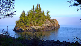
Thursday, June 8, 2017; High Falls of the Pigeon River, Grand Portage and Horseshoe Bay.
The Canadian border is less than 20 miles
from Horseshoe Bay, but it's not that which interests me, but the Pigeon River which forms
the border here, between Minnesota and Canada, and the High Falls (and coincidentally the highest in Minnesota), upon that river. This river has history written all
over it. It was this river, only 27
miles long that led to the series of lakes and streams that provided the way
into the interior of Northwest Canada, and thus the fur trading highway that
built Canada [as an aside ... I've always thought that the Canadians made a
mistake, last century, when they chose the Maple leaf as the symbol for their
national flag; the Beaver would have much more apt ... I mean, whoever built a
Nation with Maple leaves?]. But the the
first few miles of the Pigeon is blocked to canoe travel by a series of waterfalls
and rapids, of which the first is the High Falls, a couple miles from where the
river discharges into Lake Superior.
Thus Grand Portage (just a few miles down the coast from the Pigeon),
became the natural place for a transshipping point at the beginning of the 9
mile portage trail that bypassed the first few miles of the Pigeon. Here it was that the French Voyageurs from
Montreal (known as Montrealers), in their 30' birch-bark, freight canoes, with
their 8000 pounds of cargo, rendezvoused with the Voyageurs (known as Northmen), from
the far interior, in their lighter, 20', birch-bark canoes still capable of
transporting 4000 lbs. of Beaver pelts.
Here they rendezvous once a year, mightily partied-down, then went their separate ways; the Pork Eaters (another name for the Montrealers), back
to Montreal with the Beaver pelts, and the Northmen back northwest into the
interior, with their loads of trade goods to trade for Beaver pelts. Etienne Brule almost certainly stood on the
eastern shores of Lake Superior by 1608, and I like to think that some
unremarked Frenchman stood on these Minnesota shores of Lake Superior by the
time the Pilgrims landed at Plymouth Rock in 1620. I arrived at Grand Portage at closing time
for the stockade and buildings making up the replica transshipping post of the
early fur trade of 1793, but there is still much to be seen.
 |
| Morning at Horseshoe Bay. |
 |
| The Forest at my campsite. |
 |
| The trading post at Grand Portage. |
 |
| Warehouse. |
 |
| Birchbark canoe. |
 |
| Framework of an Anishinabe bark lodge; the three rolls of bark to the right of the lodge are Birchbark ready for cladding the frame. |
 |
| A fully clad smaller more tee-pee like structure. |
 |
| Beaver lodge. |
 |
| Looking out on Lake Superior |
 |
| Mist shrouding Grand Portage Island. |
The
earlier part of the day was spent at Grand Portage State Park, on the Pigeon
River, and of course going to see, and of course photograph the the High
Falls. I spent more time doing this than
I had planned, because there was a certain amount of time wasted while sheltering
from rain showers under trees, and even in a loo during the one really heavy shower. I finally did get the photos I wanted of the High Falls, even though I had to retrace my steps several times, due to the rain.
 |
| The Pigeon River. |
 |
The High Falls of the Pigeon; as it happens
this is the highest Waterfall in Minnesota
at approximately130 feet.
|
 |
| Hat Point; Grand Portage is the other side of this. |
 |
| The Susie Islands lost in fog. |
The Horseshoe Bay campsite was again
unoccupied, thus I was able to have a leisurely evening over supper, watching
fog banks come and go out on the lake, and finally the Moon rising through the
mist. This would be my last night Up
North, and I enjoyed it to the full.
 |
| Evening fogbank off shore. |
 |
| The mist closes in. |
 |
| The Moon rising through the mist. |


No comments:
Post a Comment
Thank You for your comments. If you have read "the Journey" Tab you will know that my time online is usually limited; I trust you will understand that I may not be able to reply to comments or specific questions, but that perhaps they might be addressed in future posts.